


Indian Ocean Piracy HRA reduced from 1st Sept 2021
Following the downward trend in Somali Piracy, leading shipping organisations BIMCO, ICF, INTERTANKO, INTERCARGO and OCIMF have agreed to reduce the geographical limits of the High Risk Area in the Indian Ocean, to the Yemeni and Somali Territorial Seas and EEZ on the eastern and southern limits, with effect from 1st September 2021.
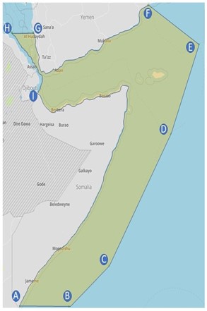
The new coordinates of the HRA are:
From position A (Latitude of 01 30’S on the Somali coast), a line to
o Position B (01° 30’ S – 046° 00’ E), a line to
o Position C (01° 00’ N – 049° 30’ E), a line to
o Position D (09° 00’ N – 055° 00’ E), a line to
o Position E (14° 20’ N – 057° 30’ E), a line to
o Position F (the Yemen coast at longitude 053° 00’ E), then
o Follow the Yemeni coast westwards and northwards, to
o Position G (the Yemeni Red Sea coast at latitude 15° 00’ N), then a line to
o Position H (the Eritrea territorial sea border at latitude 15° 00’ N), then
o Follow southwards first Eritrea’s and then Djibouti’s territorial sea borders, to
o Position I (the coastal border point between Djibouti and Somalia), then
o Follow the Somali coast eastwards and then southwards, to
o Position A.
Owners and Charterers should consider the above changes and consult with their Brokers or Latitude Brokers at [email protected] when purchasing Kidnap and Ransom cover for trading HRAs.